Sea level set-up and buoyancy-driven flows
This chapter deals with ocean circulation processes that occur in the deep ocean but are usually not of enough significance to warrant much attention. The presence of a coast magnifies these processes, giving them much more importance in coastal oceanography. They relate to the ocean's response to atmospheric forcing and can be divided into two groups.
The atmosphere forces the ocean in two ways, through tangential stress (wind), and through modification of the ocean's buoyancy (heating, cooling, evaporation, precipitation). The response of the coastal ocean to the first type of forcing is sea level set-up; the response to the second type of forcing is buoyancy-driven flow.
Sea level set-up
Wind-generated surface currents reflect the structure of the wind field on a variety of scales. On the oceanic scale the global system of Trade Winds, Westerlies and Polar Easterlies creates the large oceanic gyres that dominate the circulation of entire ocean basins. On the synoptic weather scale, atmospheric low pressure systems create storms, which introduce significant variability into the oceanic current field on time scales of days to weeks. Variations of the wind field in space generate convergences and divergences of the oceanic flow field on all scales.
In principle, a region of surface flow convergence means an accumulation of water in the convergence region. However, in the open ocean such accumulation is kept small, because a rise of the sea level from accumulation of mass immediately causes a depression of the thermocline, followed by vertical water movement from the upper ocean to greater depth. The main effect of a surface convergence is thus vertical exchange of water between the upper ocean and the underlying regions. This phenomenon is commonly known as Ekman pumping. Variations of sea level in the open ocean are therefore modest, of the order of tens of centimeters, and rarely reach 1 m in height.
In the coastal ocean the situation is quite different. To begin with, currents in the open ocean rarely oppose each other on scales of tens of kilometers, and convergences (or divergences) are usually the result of slow changes in current speed and direction. The presence of a coast inhibits horizontal water flow and produces vastly stronger convergence (and divergence) effects than are ever encountered in the open ocean. Another factor is the restricted water depth on the shelf. The depth of the coastal zone usually does not exceed 200 m or so, which poses a severe restriction on vertical water movement on a large scale. As a result, water can pile up against the coast to great height, a phenomenon known as sea level set-up or surge. Sea level set-up can pose a severe threat to coastal land and can lead to large scale flooding and loss of life in low lying coastal regions.
The major reason for sea level set-up are atmospheric storm systems. Stronger storms are of course more dangerous than moderate storms; but the severity of the resulting storm surges depends on the coastal topography just as much as on the absolute wind strength. 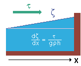 (Theoretical arguments show that when water is piled up against a coast the sea surface slope dζ/dx is proportional to the wind stress τ and inversely proportional to the water depth h; g is gravity and ρ the water density; compare the sketch on the right.) Some parts of the world's shelf regions are more susceptible to storm surges than others. Figure 4.1 shows an example of a storm surge in the North Sea. The storm system responsible for a surge in the North Sea is usually generated in the region of the Westerlies over the North Atlantic Ocean. It moves with the westerly wind in a generally north eastward direction, passing north of Scotland and continuing along the Norwegian coast. The storm produces a weak surface elevation in the open ocean, which enters the North Sea from the north and builds up to significant height as it crosses the continental slope and enters shallower water. Under the influence of the Coriolis force, which in the northern hemisphere acts to the right of the movement, the surge leans against the British coast and increases in height as it moves south towards the Dutch and German coast.
The severity of a storm surge depends to a large extent on its timing relative to the tidal cycle. Many storm systems pass quickly and produce a surge of not much more than 12 hours in duration. If the peak of the surge occurs at low tide the effect will be minimal. If, on the other hand, the peak of the surge coincides with high tide, the water level can reach quite unusual height. The most dangerous storm surges are produced by long lasting storm systems that coincide with spring tides. There have been surges during which the water level did not fall after high tide but kept rising despite of ebb tide, bringing the following high tide close to the height of the dykes along the coastline. The constant pounding from the sea under the lashing of the storm is a severe test for any dyke system. Much land can be flooded when a dyke breaks, and nothing can control the force of the water as it comes rushing in. The following table list some major flood events produced by storm surges.
| Some major historical storm surges
|
| Date
|
Shelf region
|
Estimated maximum
surge height
|
Estimate of lives lost
|
| November 1218
|
Zuider Zee (Dutch North Sea)
|
unknown
|
100,000
|
| October 1737
|
India and Bangladesh
|
12 m
|
300,000
|
| 1864
|
Bangladesh
|
unknown
|
100,000
|
| October 1876
|
Bangladesh
|
15 m
|
100,000
|
| 1897
|
Bangladesh
|
unknown
|
175,000
|
| September 1900
|
Galveston, Texas (Gulf of Mexico)
|
4.5 m
|
6000
|
| Jan/Febr 1953
|
Southern North Sea
|
3.0 m
|
2000
|
| March 1962
|
Atlantic coast, USA
|
2.0 m
|
32
|
| November 1970
|
Bangladesh
|
9.0 m
|
500,000
|
The table indicates that the two ocean regions most exposed to severe storm surges are the North Sea and the Bay of Bengal, particularly the coastline of Bangladesh. Whether a storm surge develops into a national disaster is determined by several factors. The disproportionate number of casualties in Bangladesh is to a large degree the result of the country's underdevelopment. Holland is one of the most densely populated countries of the world. Most of the country is below sea level and relies on dykes keeping the sea out. It experiences severe storm surges every year but is very rarely flooded because an infrastructure built over centuries and maintained by a rich nation secures the coastline. In comparison, the coastal defences of Bangladesh are of ancient design and the country lacks the resources to improve and maintain them.
Another factor that turns Bangladesh's storm surges into national calamities is its closeness to the equator. Atmospheric low pressure systems, which bring the storms experienced in temperate climate, can develop into cyclones in the tropics. Tropical cyclones (known as hurricanes in America) are extreme events of nature; wind and rain are very much more powerful in cyclones than in the storm systems experienced in the North Sea. Cyclones can therefore produce intense surges, with the sea level sometimes rising rapidly by several metres in a matter of hours. Figure 4.2 shows examples of sea level set-up from tropical cyclones experienced in various towns around Australia. Although none of the cyclones caused flooding with loss of life, severe flooding usually occurs with all cyclones because they are associated with record rainfall. The flooding events that occurred with storm surges in Bangladesh are to a large extent also the result of overflowing rivers following heavy rain.
Cyclones form over the sea and can create large surges when they come close to land. They often do not cross into land immediately but continue on a path parallel to the coast. This can amplify the surge if the propagation of the cyclone is in resonance with the propagation of coastal Kelvin waves. The dynamics of these waves is discussed in chapter 8, where it is shown that along the east coast of ocean basins Kelvin waves can only travel poleward, while on the west coast they can only travel towards the equator. Cyclones are features of the tropics; they form in the vicinity of the equator and move away from it towards the poles. Resonance between cyclone propagation and Kelvin wave propagation can therefore only occur on the east coast of ocean basins (the west coast of continents). Figure 4.3 verifies this for the Australian continent. It shows that sea level set-up from cyclones is generally stronger on the west coast than on the east coast.
Most cyclone tracks over the Bay of Bengal move poleward parallel to the Indian coast. Many reach landfall in Bangladesh after travelling in close proximity to the Indian coastline. This favours resonant build-up of extreme surges. Figure 4.4 shows examples of cyclone tracks over the Bay of Bengal and associated surge heights. Managing the storm surges in the Bay of Bengal remains one of humanity's greatest challenges.
Buoyancy-driven flow
The coastal zone is generally a region of increased temperature and salinity variability in the ocean, and density differences between the open ocean and the shelf are a common occurrence. Variations of temperature are enhanced through increased tidal mixing, shallow water depth and advection of warm or cold air from land. This leads to enhanced variability of the near-shore current field.
While the effect of temperature on the density field of the coastal ocean manifests itself as an enhancement of processes that occur in all ocean regions to some degree, the salinity contribution can be much more substantial. The coastal zone is not only exposed to the same freshwater balance (precipitation - evaporation) as the deep ocean; it also receives the freshwater that collects from rain over the land. This river run-off can have a substantial impact on the oceanic density field on the shelf and create its own circulation.
Figure 4.5 is a sketch of a situation where the freshwater input from land is the result of outflow from numerous rivers along the coast and can be described as a continuous freshwater source for the shelf region. Because a freshwater source lowers the density of the sea water on the shelf, the isopycnals slope downwards as they approach the shelf from the deep ocean. The resulting thermocline slope produces a geostrophic current parallel to the coast, directed equatorward on the west coasts and poleward on the east coasts of the ocean.
It is seen that river run-off from the continents produces a cyclonic circulation around the ocean basins. This circulation is generally restricted to the shelf and superimposed on the wind driven general circulation and therefore not always easily recognized in observations. On the west coasts of the ocean it is overwhelmed by the western boundary currents. In the subtropics the circulation of the deep ocean is anti-cyclonic, so the subtropical western boundary currents oppose the direction of the buoyancy driven flow, but buoyancy driven flow can occur in the form of a narrow countercurrent on the shelf. Currents on the east coasts of the ocean are generally weaker than the western boundary currents, and buoyancy driven flow can occur as countercurrents.
A prominent example of buoyancy driven flow is found along the Pacific coastline of Canada and Alaska. These coasts are in high latitudes, and the circulation in the adjacent ocean is cyclonic as part of the subpolar gyre of the North Pacific Ocean. Numerous rivers enter the ocean from the Canadian and Alaskan coast, to the effect that the continent acts as a nearly continuous line source of freshwater. The resulting buoyancy driven flow enhances the general cyclonic circulation of the region by increasing the current speed on the shelf. The strongest currents are usually found within 25 km off the coast. Figure 4.6 shows how the Alaska Coastal Current is intensified through river run-off along its path. The freshwater output from rivers amounts to only 4% of the current's transport but the current reacts with a lag of about one month, doubling its transport if the freshwater input is doubled. The variations of the Alaska Coastal Current are thus not simply the result of additional freshwater carried by the current but a response to the freshwater-induced changes in the density field.
 © 2000 M. Tomczak
contact address: