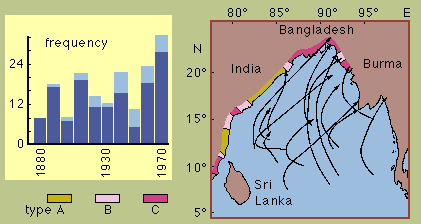
 Cyclone frequency and cyclone tracks over the Bay of Bengal.
The left diagram shows the number of severe storms that formed over the Bay of Bengal (total column height) and the number of those that made landfall (dark column parts) for 10 year periods. The years are grouped from 1877-1886 (labelled 1880) to 1967-1976 (labelled 1970).
The right diagram shows some tracks of severe storms from the period 1945-1954. The colour code along the coast indicates the exposure to storm surges; types A, B and C are defined as the response to a storm with wind a speed of 40 m s-1:
Left diagram after Mooley (1980). Right diagram after Chakravorthy and Basu (1956) and Rao (1968), adapted from Murty et al. (1986).
contact address: