 The major points to be noted here are:
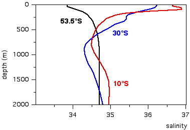
This diagram looks at salinity profiles. The major points to be noted here are:
In the polar regions salinity is lowest at the surface and increases towards depth. (This explains why temperature can go through a minimum at 100 m, as was seen in the last diagram.) at 53.5°S in the Atlantic Ocean, salinity increases from 33.85 at the surface to 34.7 at 2000 m. The low salinity at the surface is the result of ice import from the regions near the poles (Antartica and the North Polar Sea).
In the subtropics and in the tropics, the vertical salinity profile is characterised by a minimum somewhere in the depth range 600 - 1000 m. In the Atlantic Ocean this minimum occurs just below 900 m depth at 30°S, where the salinity is close to 34.3, and near 800 m at 10°S, where the salinity does not go much below 34.5. Below these depth, salinity increases with depth (which means that temperature at 10°S can indeed increase slightly from 800 m down as it did in the last diagram). Above this depth, salinity decreases with depth over most of the depth range.
Like temperature, salinity does not vary in the surface mixed layer, reflecting the effect of wind mixing.
A distinct salinity maximum is found in the tropics just below the mixed layer. It is produced by freshening of the upper ocean from tropical rainfall and therefore absent in the subtropics, where high evaporation produces high surface salinity. In the Atlantic Ocean at 10°S, the salinity maximum reaches 36.88.
Note: You do not have to remember the actual salinity values, just the general shape of the salinity profile.