PhOG, School of Marine Science, University of Maine Gulf of Maine Moored Buoy Program
Physical Oceanography Group
School of Marine Sciences
University of Maine

IOOS Home Page

Quick Looks at Gulf of Maine Realtime Data:
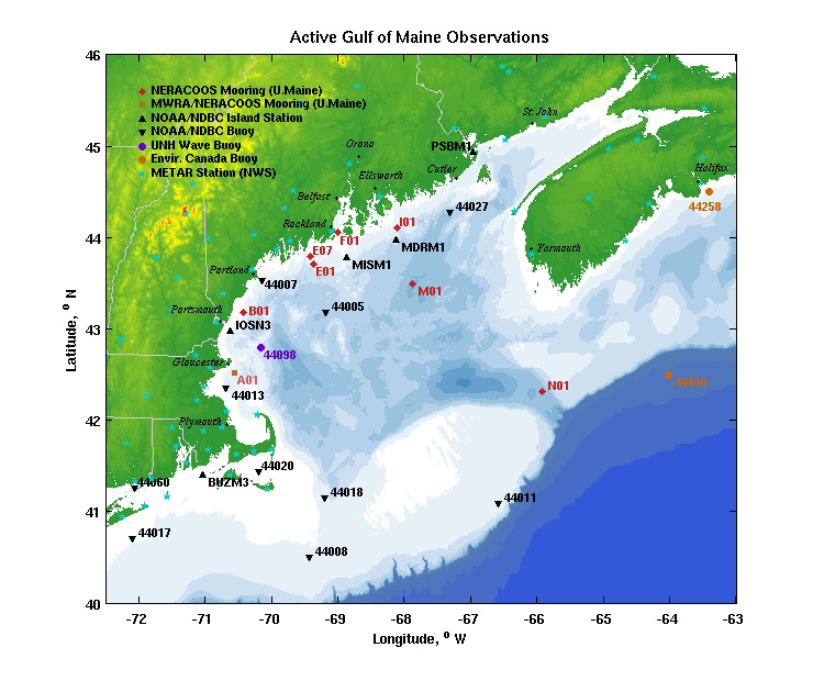
Rollover Map: Latest Hourly Data
Plots: Regional Surface Conditions from Gulf of Maine stations
Text Listings: PhOG buoys (last 10 days)
List of Active Moorings: Realtime netCDF files or Historical netCDF files
Gulf of Maine Observing Stations GoMOOS: Massachusetts Bay (A01) GoMOOS: Western Maine Shelf (B01) UNE: Biddeford (C03) GoMOOS: Casco Bay (C02) GoMOOS: New Meadows (D01) Bowdoin: Lower Harpswell Sound (D02) GoMOOS: Central Maine Shelf (E01) GoMOOS: Penobscot Bay (F01) GoMOOS: Eastern Maine Shelf (I01) GoMOOS: Cobscook Bay (J02) GoMOOS: Saint John (K01) GoMOOS: Scotian Shelf (L01) GoMOOS: Jordan Basin (M01) GoMOOS: Northeast Channel (N01) NOAA Eastport NOAA Mt.Desert Rock NOAA Matinicus Rock NOAA 44007 Portland NOAA Isle of Shoals NOAA 44013 Boston NOAA 44018  SE Cape Cod NOAA 44011 Georges Bank Environment Canada 44150 La Have Bank NOAA 44027 Jonesport Environment Canada 44258, Halifax Harbor NOAA Buzzards Bay NOAA 44005 Gulf of Maine, 78 nm E of Portsmouth NOAA 44008 SE of Nantucket NOAA 44017 SW of Montauk Pt, NY METAR KGON Groton/New London CT METAR KJID Willimantic CT METAR KBVY Beverly MA METAR KBOS Boston MA METAR KCQX Chatham MA METAR KMQE East Milton MA METAR KFMH Falmouth/Otis AB MA METAR KHYA Hyannis MA METAR KLVW Lawrence MA METAR KGHG Marshfield MA METAR KMVY Marthas Vineyard MA METAR KACK Nantucket MA METAR KEWB Mew Bedford MA METAR KPYM Plymouth MA METAR KPVC Provincetown MA METAR KTAN Taunton MA METAR KORH Worcester MA METAR KLEW Auburn/Lewiston ME METAR KAUG Auburn ME METAR KBGR Bangor ME METAR KBHB Bar Harbor ME METAR KNHZ Brunswick NAS ME METAR KIZG Fryeburg ME METAR KGNR Greenville ME METAR KMLT Millinocket ME METAR KPWM Portland ME METAR KRKD Rockland/Knox ME METAR KSFM Sanford ME METAR KWVL Waterville ME METAR KIWI Wiscasset ME METAR KBML Berlin NH METAR KCON Concord NH METAR KEEN Keene/Dillant NH METAR KLCI Laconia NH METAR KMWN Mount Washington NH METAR K1P1 Plymouth NH METAR KPSM Portsmouth NH METAR KHTO East Hampton NY METAR KMTP Montauk NY METAR KBID Block Island RI METAR KUUU Newport RI METAR KSFZ Pawtucket RI METAR KPVD Providence/Green RI METAR KWST Westerly RI METAR CYFC Fredericton NB METAR CYCX Gagetown NB METAR CWPE Point Lepreau NB METAR CYSJ Saint John NB METAR CWSS St Stephen NB METAR CWVU Brier Island NS METAR CZBD Debert NS METAR CYZX Greenwood NS METAR CYHZ Halifax Int. Airport NS METAR CWKG Kejimkujik NS METAR CXLT Kentville NS METAR CXLB Lunenburg NS METAR CXMI McNabs Island NS METAR CXNP Nappan NS METAR CWWE Western Head NS METAR CYQI Yarmouth Airport NS

Site Location Start Date Latitude Longitude Mooring Status Light List Letter Light List Number
A01Massachusetts Bay2001-07-1042° 31.34´N070° 33.89´W2009-10-27A367
B01Western Maine Shelf2001-07-0943° 10.88´N070° 25.65´W2009-09-24B113
E01Central Maine Shelf2001-07-0943° 42.81´N069° 21.41´W2009-09-16E30 (4935)
F01Penobscot Bay2001-07-0844° 3.25´N068° 59.87´W2009-09-17F4052
I01Eastern Maine Shelf2001-07-2444° 6.31´N068° 6.58´W2009-10-02I2296
M01Jordan Basin2001-07-1243° 29.36´N067° 52.27´W2009-10-02M6
N01Northeast Channel2004-06-0342° 19.57´N065° 54.43´W2009-11-09-
PR1CarICOOS Data Buoy A2009-06-0917° 51.61´N066° 31.43´W2009-06-09A

Funding Partners:NeRACOOS Home PageGoMOOS Home PageU.Maine Home PageBowdoin UniversityUniversity of New EnglandIOOS Home Page


March 2009: Federal funding shortfalls have resulted in the removal of buoys C02, D01, J02, and L01. Buoy F01 is also in jeopardy of being removed, although funds have been found to keep it deployed until fall 2009. Please contact Dr. Neal Pettigrew (nealp@maine.edu) with suggestions for additional funding to keep these important buoys active.

October 2008: University of Maine is funding Gulf of Maine buoy F01.
May 2008: New Meadows buoy D01 has been removed due to lack of funding.
October 2007: GoMOOS funding from the NE Gateway LNG Project is supporting Gulf of Maine buoy A01 (maintained by the University of Maine).
July 2007: NERACOOS is now providing funding for the Gulf of Maine buoys B01, E01, I01, M01 and N01 (maintained by the University of Maine).
October 2006: New Meadows buoy D01 established downriver from Cundy's Harbor.
October 2006: Dual wind sensors on all GoMOOS Gulf of Maine buoys.
October 2004: Barometric pressure measurements added to all GoMOOS buoys.
June 2004: A new site N01 has been established in the Northeast Channel, south of Browns Bank. Available data from this mooring include surface winds, waves, air temperature, and visibility as well as ocean temperature and currents at selected depths down to near-bottom.
October 2003: The GoMOOS mooring K01 (Saint John, New Brunswick) has been recovered. Due to funding shortfalls, it is not planned to redeploy another mooring at this time. Historical data are still available.
13 March 2003: Buoy L New Location Notice

NOAA's National Data Buoy Center (NDBC) operates and maintains the sites in black. on the above map.
Environment Canada operates and maintains site 44258 (in blue).
Wave modeling results are also available for the Gulf of Maine (Texas A&M)
Link to Current Moorings: Active files or Historical

Mooring Program Field Work:

Buoy A at sunsetRecover of Buoy N on R/V Delaware, April 2005Repair of buoy A on R/V Tully, Feb 06
Operations during 2005 on R/V Argo Maine and Delaware; Buoy A repair on F/V Tully IV
(Photos courtesy of J.Wallinga(UME), S.Wagner(NOAA), and J.Wallinga (UME))

References:

Questions? Contact the Webmaster

NERACOOS Home Latest Buoy Data U.Maine Buoys U.Maine CODAR GOM Weather GOM Wave Modeling Related Links Software Mooring Group PhOG home