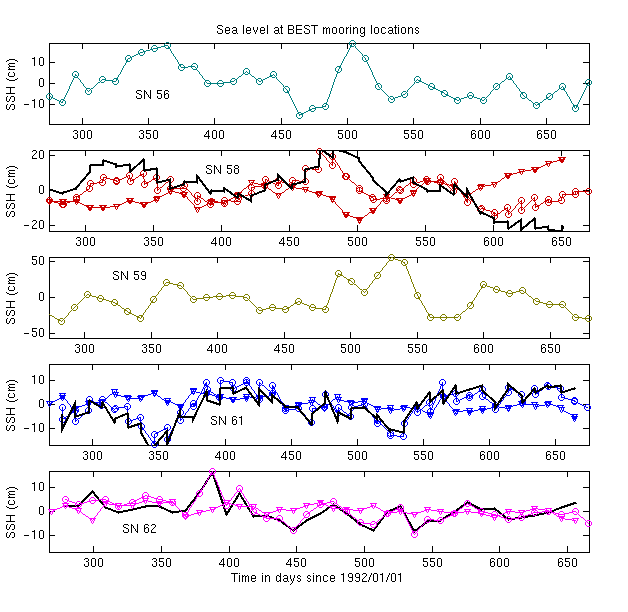
Altimetric sea level is the sum of several components: steric height, which is the signal of interest and is related to the density field of the water column, barotropic tidal sea level (a high-frequency component), and low-frequency barotropic variability. In this plot, timeseries of altimetric sea level at the BEST IES mooring locations are shown (circles). Several (but not all) of the BEST IES moorings were equipped with bottom pressure sensors. For these moorings (b,d, and e), the low-frequency barotropic sea level signal is also shown (triangles), computed using the hydrostatic assumption. Where this information is available, the barotropic sea level is subtracted from the altimetric signal for the steric height (SSH) estimates. This has been done for SN 58, SN 61, and SN 62. The corrected SSH is plotted with a thick black line. Steric height estimates at SN 56 and SN 59 remain uncorrected as these moorings lacked bottom pressure recorders. This will add to the uncertainty of the GEM-ETTA temperature and salinity estimates at these two locations.
Each altimetric timeseries has been corrected for barotropic tides using the CSR 3.0 tide model [Eanes and Bettadpur, 1996]. While relatively accurate this model leaves a residual signal of up to several cm in the altimetric record [Byrne, 2000]. For the ASTTEX deployment, the in situ pressure records will be used to create more accurate tidal corrections for altimetric sea level.
| Raw Data Records (Figs. 8-15) | |||||
| Echo Sounder Data | IES 56 | IES 58 | IES 59 | IES 61 | IES 62 |
| Bottom Pressure Data | N/A | BP 58 | N/A | BP 61 | BP 62 |