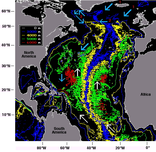
In the North Atlantic Ocean, Antarctic Bottom Water continues its northward movement across the equator (the white arrows).
Arctic Bottom Water is produced in deep basins north of the Greenland - Iceland - Scotland Ridge (1), which is shallower than 3000 m and inhibits its continuous southward movement. This water therefore enters the Atlantic Ocean in bursts when it is lifted over the ridge by strong storm systems. Its progress is shown by the aqua-blue arrows.
The western branch of Arctic Bottom Water flow, which enters the Atlantic Ocean between Greenland and Iceland, follows the Greenland shelf westward. The eastern branch enters between Iceland and Scotland and follows the Mid-Atlantic Ridge until it finds a passage to the west, the Gibbs Fracture Zone (2). It then joins the western branch into the Labrador Sea (3), where both are mixed with freshly sinking winter water. The resulting water mass, known as North Atlantic Deep Water, moves south.
(Map based on the GEBCO97 database, produced with GEBCO97 software and modified.)