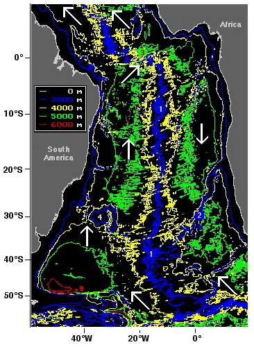
This more detailed map of the South Atlantic Ocean, which uses the same colour scheme as the previous maps, shows the movement of Antarctic Bottom Water into the Atlantic Ocean (white arrows).
The Mid-Atlantic Ridge (1) stands out clearly. Antarctic Bottom Water moves northward on either side of it. In the east, this movement is blocked by the Walvis Ridge (2), which connects the Mid-Atlantic Ridge with the African shelf. As a consequence, Antarctic Bottom Water reaches the Atlantic basins north of the Walvis Ridge not from the south but from the north, through a narrow depression in the Mid-Atlantic Ridge at the equator, known as the Romanche Fracture Zone (3).
The Rio Grande Rise (4) is separated from the South American shelf by a passage deep enough to let the water through. It therefore does not present a barrier to Antarctic Bottom Water flow.
(Map based on the GEBCO97 database, produced with GEBCO97 software and modified.)