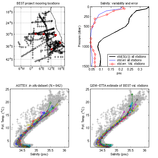
Figure 6 a,b,c,d.
a) (top left) Locations of BEST IES moorings (red), and locations of of hydrographic stations in the database that were used to create GEM-ETTA parameterizations for the Cape Basin (black crosses). Fourteen stations which were occupied during the BEST experiment at the BEST mooring locations were removed from the database and used as a test population to validate first the GEM-ETTA fields (using "exact" values of SSH and tau calculated from hydrography) and then (Fig. 19) the method itself (using SSH and tau derived from the combination of IES moorings, satellite altimetry and bottom pressure).
b) (top right) Variability of S(z) and T(z) in the Cape Basin, compared with rms error for the entire parameterization (blue) and for the test population (red). The upper ~150 m are prone to seasonal fluctuations, contributing to the high rms error of GEM-ETTA estimates there. The addition of a seasonal decomposition, a refinement not yet attempted, is expected to account for most of the error. The rms error between the GEM-ETTA estimates and the individual profiles used to create them provides a measure of the error in GEM-ETTA-derived thermohaline fluxes.
c & d) (bottom left and bottom right) c) T-S curves for the test population plotted from in situ data. d) The same, plotted from GEM-ETTA parameterizations.