Air temperature at Eucla (on the coast at 129°E) during February 1991.
The high temperature surface water was traditionally believed to be advected into the Bight from the Leeuwin Current, a poleward eastern boundary current which flows along the continental shelf edge of Western Australia (Tomczak and Godfrey, 1994). The Leeuwin Current brings tropical water to the southern parts of Western Australia. It is strongest in April/May, when it rounds the south western tip of the Australian continent and enters the Bight.
A sequence of satellite images (Figure 3) reveals that the origin of the warm surface water mass is an extensive shallow region in the north west of the Bight. During winter this region is of comparable temperature to the open ocean (Fig. 3a). First warming over shallow topography is observed in November (Fig. 3b). The warming intensifies towards January (Fig. 3c). During the next three months the locally formed water mass is advected eastward across the shelf (Fig. 3d) towards the shelf break (Fig. 3e). The Leeuwin Current is seen to enter the region in late April (Fig. 3f), well after the warm water mass is established. It dominates the sea surface temperature field by July (Fig. 3g).
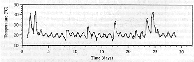
A detailed analysis of the heat budget shows that "hot events " when the wind carries hot continental air across the Bight contribute significantly to the heating process over the shallow water. The air-sea temperature difference during such events can reach up to 15°C. The events last for two to three days; the figure shows 4 - 7 events during February 1991:
Air temperature at Eucla (on the coast at 129°E) during February 1991.
The process of local water mass formation and eastward advection of the warm water was verified through numerical modelling which forced the Bight with a surface heat flux and a wind stress field corresponding to the west to east passage of anticyclones. If was found that the location of the cyclone paths was critical for the establishment of a sea surface temperature field resembling the observations (Figure 4). A track too close to the Head of the Bight produced a warm plume which followed the coast, a track too far south resulted in only a small plume, part of which was advected westward out of the Bight. Only an anticyclone path which follows the inward curving track of observed weather systems produces the observed sea surface temperature field.
© 1998 M. Tomczak
contact address: