Atlantic Water Masses and the Conservation of T and S
For the questions and exercises below, you'll use the following three hydrocasts,
which were taken at different latitudes along 30.5W in the Atlantic Ocean.
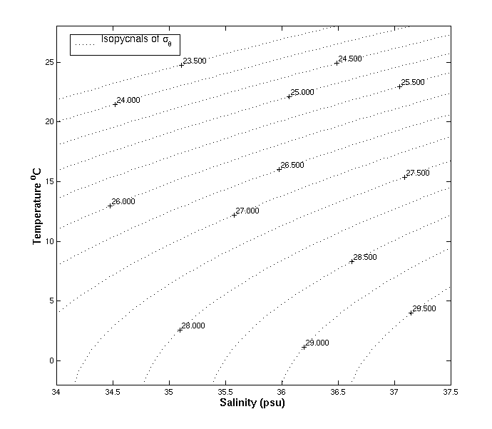
You'll need this T-S chart:
And you'll need the following information:
-
Antarctic Intermediate Water (AAIW), which is formed around 50S
at the Antarctic Polar Front, has a salinity of 34.25 psu and a potential
temperature of 3.5C. AAIW is defined as the salinity minimum layer
below the thermocline.
-
North Atlantic Deep Water (NADW) has a salinity of 34.95 psu and
a potential temperature of 3C, and is formed around 60N in the Labrador
and Greenland seas. NADW is defined as the salinity maximum layer below
AAIW.
-
Antarctic Bottom Water (AABW) is formed at about 65S near the Antarctic
Continent. It has a salinity of 34.65 psu and a potential temperature of
-0.25C. AABW is defined as the temperature minimum layer below NADW.
-
As a water mass travels further from its source it will mix
isopycnally,
meaning along a surface of constant density, and to a lesser extent with
water masses above and below it; the further it travels from its source
the more its unique T-S values will erode and become indistinct.
Questions and Exercises for Part I
-
Please plot the three stations in T-S space on the T-S chart above. Be
sure to identify which station is which.
-
Please plot the core T-S values of AABW, NADW, and AAIW on the same graph.
-
Using the water mass information, which station comes from the furthest
south? How do you know?
-
Which station comes from the furthest north? How do you know?
-
At approximately what pressure is the core of each water mass found?
-
Where would the water masses from the Gulf of Maine be located in T-S space
in relation to the water masses and casts you plotted here? See Homework
problem 12 if you don't remember the T-S characteristics of water masses
in the Gulf of Maine.