|
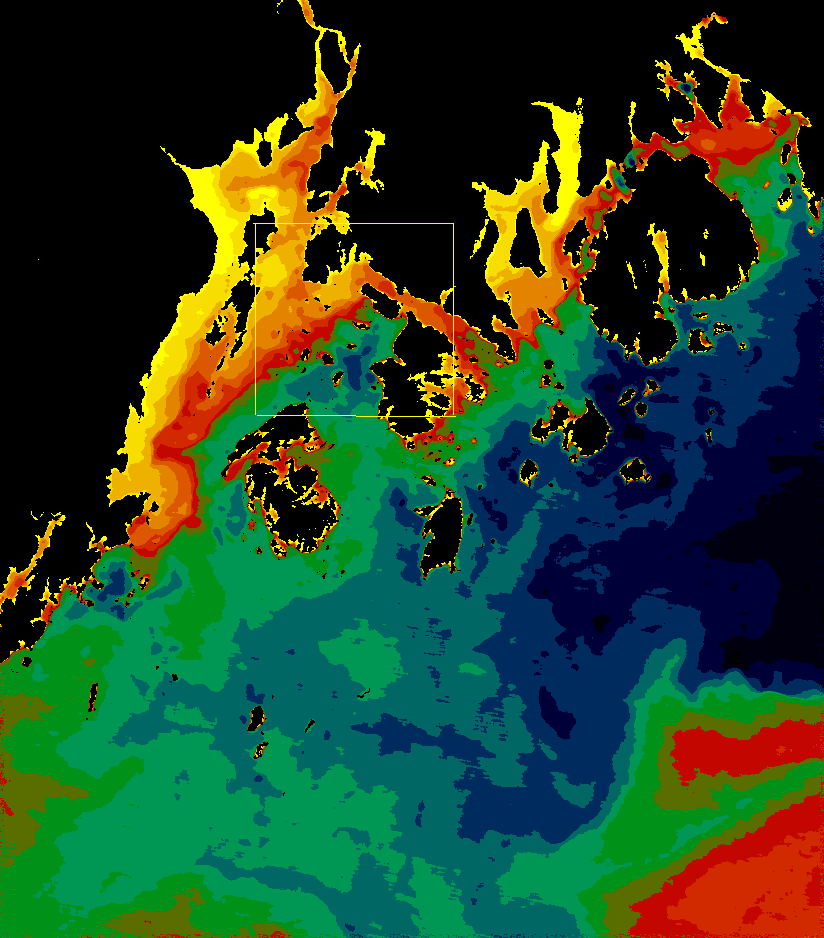
Landsat TM Band 6 (thermal infrared), 27 June 1995 The coldest water is blue, the next coldest water is green, followed by red; the warmest waters are yelow.. A strong front is visible between the edge of the Penobscot river outflow and cooler water from offshore sources. The cold Eastern Maine Coastal Current (navy blue) turns offshore just outside the Bay. This image was taken on an incoming tide. The outlined area visible in the full-size version of the image is enlarged below. |
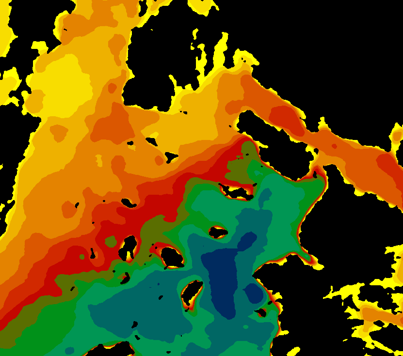
| Focus on the Eggemoggin Reach/Cape Rosier area. Notice how the front mentioned above divides the Bay along the East Channel into two very distinct regimes. | |
What is satellite SST and how can it be used?
Satellite SST is a thermal image of the ocean's surface. It is a snapshot of a particular moment which includes the effects of winds, tides, currents, local heating and cooling of the ocean's surface by the sun and atmosphere, and even (unwanted) atmospheric effects such as haze, clouds, fog, or sun-glint. The ocean is a dynamic medium, and, depending on the conditions that obtained at the time a particular image was made, it may or may not provide a picture of typical or characteristic features and conditions. For example, imagery obtained during the passage of a hurricane would not provide a good look at typical SST patterns; on the other hand, if the subject of interest is the effect of hurricanes on air-sea interaction, then only imagery collected during hurricane conditions would be appropriate. This simple example underscores the caveat that additional information, and experience on the part of the analyst, is usually essential to the intelligent interpretation of satellite SST imagery. Often in satellite studies of the ocean, large numbers of images are used to provide statistical measures of the strength and frequency of recurring patterns, helping to determine their significance.
Because the ocean is relatively opaque to infrared (IR) wavelengths, an IR image of the ocean's surface measures the temperature of the top few millimeters, at most. Satellite SST thus measures what is know as the "skin temperature" of the ocean, containing temperatures and spatial patterns which may not be indicative of what lies beneath. A satellite SST image is akin to a color photograph of a wall -- the photo will indicate what color the wall has been painted, but not what kind of insulation was used or how many layers of paint lie underneath the topmost one and in many applications, the temperature at lower depths of the ocean is much more significant than the skin temperature. Particularly in summer, significant temperature gradients can exist in the top few meters of the ocean, essentially "disconnecting" satellite SST from the temperatures below the skin layer and their spatial patterns. On the other hand, mixing of the ocean's surface layers by wind or tide in many cases will prevent such a gradient from forming. Measurements made at buoys and from ships sample at least the top few centimeters of the ocean, and quite often the temperature along the entire depth of the water column is sampled. Again, oceanographers must thus use their knowledge of how the ocean behaves, as well as additional sources of data, to interpret satellite SST imagery intelligently.
In this case, the temperature front seen in the above image is not uncommon
in Penobscot Bay in the summer; the warmest water is in this image is quite
likely the result of the Penobscot River outflow and relatively fresh as
well, and the colder SST's are likely to be indicative of colder temperatures
and more saline water throughout the water column. Subsurface measurements
made by Maine Maritime Academy instructors and students indicate the warm,
fresh layer can be up to 15 meters deep.
Copyright © 2001 Deirdre Byrne, University of Maine