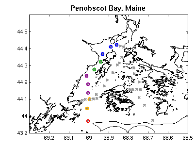
The following hydrographic data are from Maine Maritime Academy student
cruise on September 25, 1992. The stations you will be working with are
from the west side of the bay and are shown with colored circles here:
Homework Questions Use the figures below to answer the following
questions
-
Which property, salinity or temperature, is principally determining the
density field? How did you reach that conclusion?
-
If you were going to model the west side of Penobscot Bay as a 2-layer
estuarine system, at which density level would you separate the two layers
and why? Note: You will need to use both density and salinity fields to
answer this.
-
Roughly speaking, what is the average density in each of the layers you
chose in the previous question?
-
Given a rms tidal velocity, Ut, of 0.5 knot, and an average width, b, of
16 km for the Bay, and an average of 9.5 million cubic meters of freshwater
per tidal cycle (12 hours) coming in to the bay from the Penobscot River
(this value is a 10-year climatological average for the month of September),
what is a reasonable value for the estuarine Richardson number:
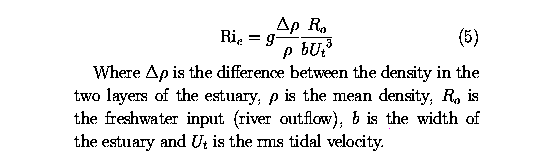
for Penobscot Bay in September? NOTE: If you don't have your conversion
sheet handy, for converting from knots (nautical miles per hour) to m/s,
use the facts that 1 n.m. = 1.16 standard mile, and 1000 m = 0.6 standard
mile. Show all of your work. BONUS QUESTION (0.25 pt): why are tidal
velocities often given in knots rather than units like cm/s or m/s?
-
If (one-way) entrainment into the upper layer occurs when Ri > 0.5, and
two-way turbulent mixing occurs when Ri < 0.5, which do you expect to
occur in this part of Penobscot Bay in September?
-
For Penobscot Bay R/V (ratio of river input over one tidal cycle to tidal
prism volume, or volume of water brought in on the flood tide) is on the
order of 0.005 - 0.007. Yet the west side of the bay shows some characteristics
of a highly stratified estuary rather than those of a partially mixed estuary.
Why might this be? (Hint: while an estuary like the Chesapeake might 10
m deep, Penobscot Bay averages more like 60 m).
-
BONUS QUESTION (0.5 pt): What are the mean temperature and salinity of
the salt wedge coming in to Penobscot Bay? What proportion of the west
bay is occupied by the wedge? What temperature and salinity would you expect
to find at depth in the waters just outside the mouth of Penobscot Bay?
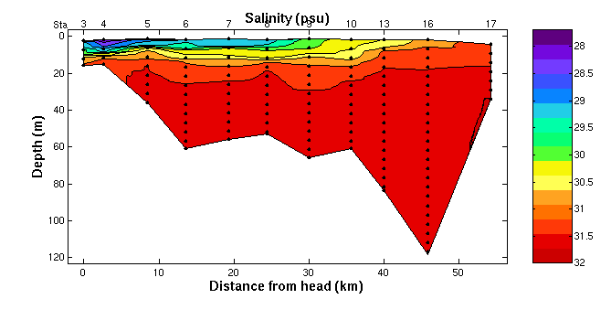
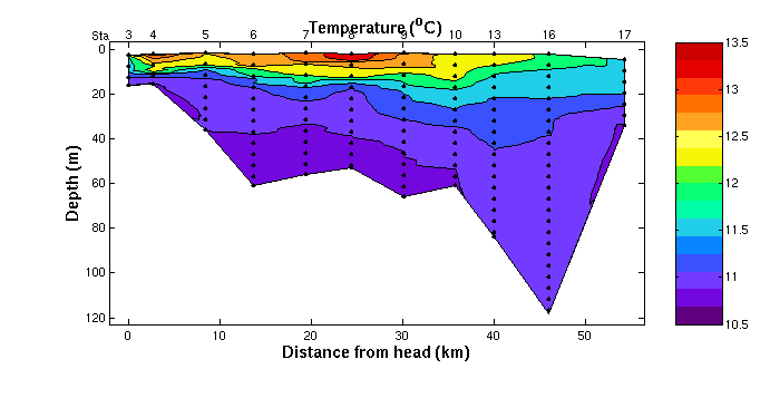
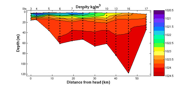
Here are the figures you'll need to work this problem. This type of plot
is called a hydrographic section. The x-axis is distance along the
transect (elapsed distance that the ship has travelled from station to
station) from the head of the bay to its mouth. The y-axis is depth. The
contours are of temperature, salinity and density, respectively. The color
code is to the right on each section, and the black dots indicate the locations
of the measurements. In reality, measurements were taken every meter, but
I have plotted only every tenth measurement, for clarity. The station
numbers (station number is a reference number for all the measurements
taken at a given geographic location) are plotted along the top (3 4
5 ... 16 17).