- General Buoy Description
Two Ocean Data Acquisition System (ODAS)
moorings were deployed on the lower
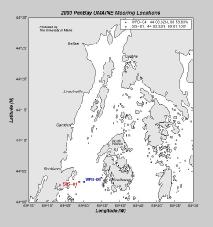
west side of Penobscot Bay on 10 July 2000 from the R/V Argo Maine. The
moorings were configured with a surface float and tower. Each buoy was equipped with
a solar-powered GPS and data telemetry unit, radar reflector, and a lantern. Both
moorings were recovered on 7 July 2001 by the R/V Connecticut.
At a depth of 2 meters on each mooring, a 3D-ACM coastal current meter from
Falmouth Scientific, Inc. measured near-
surface current speeds and directions with a 2-minute burst sample every 30 minutes.
A RD Instruments 300 kHz Workhorse
Sentinel Acoustic Doppler
Current Profiler (ADCP) was mounted in a down-looking configuration
three meters below the surface floats. The ADCPs on each mooring were programmed
to sample the water velocity at discrete time and depth intervals and then
average those samples in time and depth. Samples were collected at a rate of
3 hz and averaged every 30 minutes on each mooring. The depth cell length was
4 meters for each mooring, with the first bin centered at a depth of 10
meters. One mooring (WPB-04) was equipped with an
RM Young wind and air temperature sensor.
Wind samples were integrated over one minute and then averaged every 30 minutes.
current and surface meteorological data are sent to a
Campbell Scientific data logger which
transmited the data daily via a cell phone link to the University. The data logger on
SIS-01 stopped transmitting in September 2000 and the data logger for WPB-04 stopped
transmitting in late April 2001. Three SBE
16-03 Seacats from Sea-Bird, Inc. were
internally recording temperature and conductivity (T/C) samples at a sample rate
of one sample every 15 minutes. These were attached to the moorings at depths of
1 meter, 8 meters, and 40 meters plots are available for
temperature,
salinity, and density.

